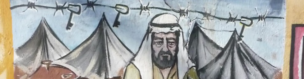
Palestine Remix: videos, maps, drone footage. Palestine Remix puts dozen of documentaries on Palestine at your fingertips, allowing you to view or use parts of various films to create your own productions. Using cutting-edge technology that synchronizes text and video, you can instantly find anything mentioned in the films. Explore the modern history of Palestine in an easy-to-use format. Click on any year in our timeline to discover the story’s milestones and major players. Watch amazing drone footage high above historic Palestinian towns. Explore a data visualization that highlights how and when hundreds of villages were destroyed, turning hundreds of thousands of Palestinians into refugees overnight. Vanishing Palestine is an interactive map that summarizes in one minute how Palestine was colonized – and what the land looks like today.
Across the Wall: Israeli Settlement Bus Routes — Visualizing Palestine has released a new map of the Israeli bus routes that connect the illegal settlements in the Occupied Palestinian Territories with Jerusalem. It also clearly shows where the “security wall” has been built, leaving no doubt that the true intention is annexation of Palestinian land, not security. If a picture speaks 10,000 words, then this map speaks 1,000,000 words.
The Fluid Borders of Palestine –Three maps show how Palestine has been whittled away. The first is the 1947 UN Partition Plan. The second shows the Occupied Palestinian Territories, commonly referred to as the OPT. And the third map illustrates the current Palestine Bantustan. Prepared & designed by Michael Younan. From the website of the Israeli Committee Against House Demolitions. Other maps depicting the Bantustans are here.
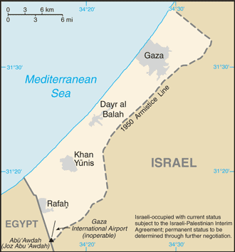
Gaza in 2003 — A good historical map of Gaza before Israel evacuated the settlements. This shows the “security zone” around the inside perimeter, the refugee camps, and the Gaza International Airport which Israel destroyed in 2001-2002. Source: theglobaleducationproject.org
Water Systems — A map showing the watershed and some of the water systems in Israel & Palestine. Water usage is a huge source of conflict in Israel & Palestine.
Gaza Strip border crossings — This map shows six border crossings between Gaza and Israel/Egypt. There are only two (Rafah and Erez) crossings for people. The others are for transporting goods and supplies. Israel controls all of the crossings with the exception of Rafah which is controlled by Egypt. However, some people believe there is coordination between Israel and Egypt at Rafah. The Palestinians in Gaza cannot leave without approval from Israel or Egypt. People cannot enter without approval either. Gaza is accurately described as the “largest open air prison in the world.”
Mental Maps — I stumbled upon this blog post with very interesting information about Israeli and Palestinian maps.
Compilation of 40 Maps that tell the story of the Middle East. This is a gold mine. Check it out here and here.

Awaiting moderation, that must be why there are no comments, you delete opposing opinions?
“Awaiting moderation” simply means that your post does not automatically appear until I have approved it. But please don’t jump to the conclusion that I delete posts with which I disagree. I have a policy of posting all comments. To my knowledge, I have only rejected one message and that was from a young person who posted his/her phone number in the message. I don’t think such personal information belongs on a blog.
Laura, your maps speak but you are not listening. For example, the bus route map is simple. The settlements beyond the security fence will not be included in Israel is there is a final peace agreement. The fluid borders of palestine tell another story. The arabs were offered the much larger state in 1947 and rejected it. The palestinians and 5 arab armies attacked israel. Similar story in 1967. The third map is also informative, (though not accurate), if the palestinians are not agreeable to a settlement, future terms will be less favorable. As for the border crossings, after Israel withdrew from Gaza Strip, Hamas attacked with bombs. In fact, go to the Rafa border (I have), and you will see what looks like a large empty airport terminal (without the runway). Israel built this building to support cross border traffic, but your buddies in Hamas bombed it and Israel had to close it. And just for the record, Abbas, the so called moderate, demands as a precondition to “negotiation”, that Israel accept 5 million palestinians into Israel (almost none of whom were born there). In other words, he accepts a two state solution in which both states have an arab majority. Netanyahu has stated he proposes a two state solution, one arab and one jewish. Abbas will not meet until Netanyahu “accept” his demands.
Your information is wildly divergent from the information I have …. and so I wonder what sources you are getting your information from.
I won’t try to refute your points one-by-one, but please understand there is credible and independently-verified information that contradicts your statements re. the airport at Rafah (yes…I have been to Rafah 5 or 6 times), about the historical events in 1947 and 1967, and about the current “demands” that Abbas is making for negotiations to begin.
I am willing to read your sources ….. if you will read mine. Let me know and I’ll go to the trouble to post some for you.